
Heatwaves in farming: what happens to crops at +38 °C and what you can actually do
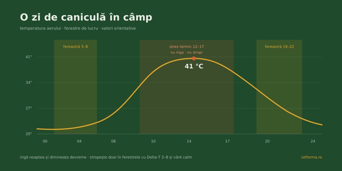
August 2026 brought red heat warnings to Romania again: 40–41 °C across multiple counties, extended day after day. For a city, a heatwave is a news item. For a farm, it is a week in which the crop demands the most water exactly when the soil holds the least — and in which a few well-timed decisions separate a saved season from a shortened one.
The good news: heatwaves do not strike unseen. They show up in the forecast 2–3 days ahead, and they show up in the data — if you have somewhere to look.
What heat actually does to the plant
Two things happen at once on +38 °C days, and both cost yield:
The plant shuts its valves. Above a temperature threshold (roughly 32–35 °C for most field crops), the plant closes its stomata to stop losing water. With stomata closed, no carbon dioxide comes in either — photosynthesis slows or stops. The plant is no longer producing, only surviving. In maize, if the heat hits pollination, the damage is permanent: pollen loses viability above ~35 °C, and kernels that fail to set today never set at all.
The air pulls water by force. The number that describes this is VPD — vapour pressure deficit, the air’s “thirst”. At 38 °C and 25% humidity, VPD passes 4 kPa: air that pulls water out of leaves and soil far faster than roots can replace it. The crop’s daily consumption (evapotranspiration) climbs from 4–5 mm per day to 7–8 mm — nearly double. A soil reserve that had 10 days left suddenly has 5.
We covered the mechanics of the water reserve in the drought article — a heatwave is drought’s fast cousin: drought empties the reservoir in weeks, a heatwave in days.
Irrigating in a heatwave: when and how
The first rule is counterintuitive: you do not irrigate when it is hottest. At midday, a significant share of the water evaporates before reaching the roots, and on some systems sprinkling in full sun also means thermal shock on the leaves. The good windows are night, early morning, and the evening after 7 pm — the water goes into the soil, not the air.
The second rule: water deeper and less often, not little and often. Small frequent doses during heat maintain shallow roots — exactly the layer that overheats and dries first. A larger dose that reaches 30–40 cm feeds the roots where the soil stays cool.
Third: prioritise by crop stage, not by how the field looks. Maize at pollination–grain fill and sunflower at flowering take absolute priority — there, every day of stress cuts directly into yield. A field in a less sensitive stage can wait a few days without major loss. The exact maize calendar is in our maize irrigation guide.
And the number you dose by is not “what the neighbour applies” but the balance: what the crop consumed yesterday, what rain fell, what is left in the soil at root depth. Soil moisture sensors give you that number, per field.
Why you never spray at midday in a heatwave
Heat wrecks the treatment calendar too, not just the watering one. At 35+ °C in dry air, the spray droplet evaporates before it can stick to the leaf — the treatment goes into the air, and what does land on a scorched leaf can burn it. Agronomists use an indicator called Delta-T for this: the difference between air temperature and wet-bulb temperature. The good spraying window is Delta-T between 2 and 8 — at midday in a heatwave, Delta-T passes 9–10 and stays there for hours.
Then there is wind: heatwaves often end in storms (it is no accident “strong wind” trends next to “heatwave” in searches), and gusts carry the spray far from your rows. The practical conclusion: during heat, the real spray windows are early morning and late evening — and they close fast. You can check the 3-day windows for your locality free with our spray-weather tool. The platform computes them continuously from the station’s data — average wind and gusts, Delta-T, rain — and tells you “now is fine” or “window later”, instead of leaving you to guess.
The signs show in the data before they show from the tractor
From the field, heat stress shows late: leaves curling at noon, a dull colour. In the data, it shows days earlier:
- the forecast announces the heatwave 48 hours ahead — the platform sends a heatwave alert so you protect what is sensitive and schedule watering before the peak;
- VPD climbs past stress thresholds through midday — a sign the plant has closed its stomata even while the soil still holds water;
- daily consumption rises visibly in the water balance — the reserve that “had two weeks” changes its deadline in front of you;
- soil moisture drops first at 30 cm, then at 60 — and once it drops there too, you are already in field-triage territory.
The difference is not cosmetic. Whoever sees the heatwave in Wednesday’s forecast irrigates Thursday night, before the peak, with water that actually enters the reserve. Whoever sees it on the leaves on Saturday irrigates in crisis, in full heat, at half the efficiency.
Heatwaves are prepared for in February
Like drought, a heatwave is hard to manage from the middle of it and much easier ahead of time: heat-tolerant hybrids, sowing dates that keep pollination away from the July–August peak, a monitoring network sized before the season. All of it is in the 4-step anti-drought strategy — valid word for word for heatwaves too.
And if you want to see what a heatwave day looks like in data — VPD, Delta-T, water balance, spray windows — the platform has a demo version with simulated data.